The North Carolina coastline stretches some 325 miles along the mid-Atlantic and boasts dozens of barrier islands large and small. These include the Outer Banks—a thin chain that includes Cape Hatteras National Seashore and the Pea Island National Wildlife Refuge, along with eight villages that are popular vacation destinations.
As in many coastal communities worldwide, residents of low-lying islands along the North Carolina coast struggle to maintain a robust infrastructure in the face of a rising sea. And sea level is rising faster here than the global average, partly because the land is also subsiding.
This profile is excerpted from the 2014 report, Encroaching Tides: How Sea Level Rise and Tidal Flooding Threaten U.S. East and Gulf Coast Communities over the next 30 Years.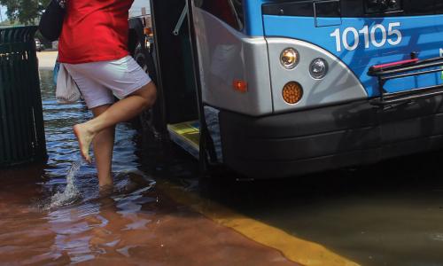
Encroaching Tides
NOAA’s tide gauge at Duck, NC, records around eight tidal flood events a year, mostly during full and new moons. Along the mainland-facing side of the Outer Banks, wind-driven tides from Pamlico Sound can also bring flooding, particularly in fall, winter, and spring.
Highway 12, a National Scenic Byway, links the Currituck, Dare, and Carteret peninsulas with Roanoke Island and the Outer Banks. Over time, storm surge from nor’easters, tropical storms, and hurricanes—including Isabel, Ida, Irene, and Sandy—has damaged or washed away miles of this highway. Costly efforts to keep it open are an example of the challenge of maintaining infrastructure on a barrier island in the face of frequent storms and rising seas.
Says Carol Dillon Dawson, a motel owner and sixth-generation native: “Sea level rise makes storms worse for us, and the lack of access because of bridge and road closures puts our communities at risk, with no emergency services able to reach us.”
The rate of sea level rise along this part of the East Coast is increasing. By 2030, just 15 years from now, projections show that Duck will face a tripling of flooding events—to more than 30 per year. By 2045, sea level may be more than a foot higher, threatening more property and posing greater risks to residents.
North Carolina communities are already taking steps to build resilience to storms, such as by nourishing beaches, building dikes, raising houses, and relocating roads, and many of those measures will also help with sea level rise and tidal flooding. Coastal erosion and sea level rise prompted the National Park Service to take action in 1999 to save the Cape Hatteras Lighthouse by moving it inland. However, communities will need to pursue other measures to protect infrastructure, housing, and wildlife habitat over the longer term.
In May 2014, the North Carolina Coastal Resources Commission asked the state Science Panel on Coastal Hazards to produce a report on sea level rise based on 30-year projections. That report will help North Carolina join other coastal states in tackling this immense challenge. Communities on the Outer Banks and elsewhere will need the best available information and a willingness to work with nature’s power, not against it, in dealing with the pace of sea level rise.
Related resources

2024 Annual Report

Inside Multnomah County's Climate Lawsuit

A Path Forward