Climate change is rapidly worsening tidal flooding, threatening essential and costly coastal infrastructure that millions of people depend on.
Research led by the Union of Concerned Scientists shows that between now and 2050, climate change–driven sea level rise will expose more than 1,600 critical buildings and services to disruptive flooding at least twice per year.
This flooding is a particular threat to public and affordable housing—a burden borne inequitably. More than half the infrastructure at risk by 2050 is in communities at a disadvantage based on historical and ongoing racism, discrimination, and pollution.
How much infrastructure will be in jeopardy late this century will depend heavily on the choices countries make about global heat-trapping emissions. Policymakers and public and private decisionmakers must take immediate, science-based steps to safeguard critical infrastructure and achieve coastal resilience.
Looming Deadlines for Coastal Resilience
This is an online version of the report. For the full text, please download the PDF.
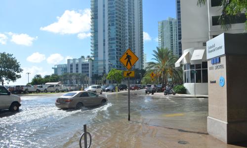
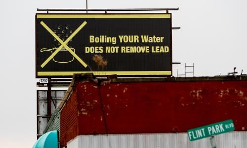
Critical infrastructure up and down the coastlines of the United States is increasingly under assault from flooding during high tides as climate change--driven sea level rise brings water further into coastal communities. In Norfolk, Virginia, the razing of a public housing development due to coastal flood risks has forced former residents of Tidewater Gardens to fight to secure their right to return to new affordable housing in the community (Murphy 2021). In Charleston, South Carolina, sewer overflows due to tidal flooding have sent unhealthy, partially treated wastewater into nearby waterways (Shailer 2024). And in Miami, Florida, which currently experiences routine high tide flooding and is acutely at risk from sea level rise, a building boom continues despite the billions of dollars of infrastructure already in harm's way (Iacurci 2024).
Even without storms or heavy rainfall, high tide flooding—"sunny day" flooding—driven by climate change is accelerating along US coastlines. It is increasingly evident that much of the coastal infrastructure in the United States—including K--12 schools, electrical substations, emergency services, public housing, and brownfields—was built for a climate that no longer exists. Assets that were safe when constructed are now at risk of being regularly inundated with seawater.
As sea level rise progresses, disruptive flooding will imperil thousands of critical buildings and facilities sited along US coasts. That flooding could interfere with the provision of essential community services and expose communities to harmful pollutants.
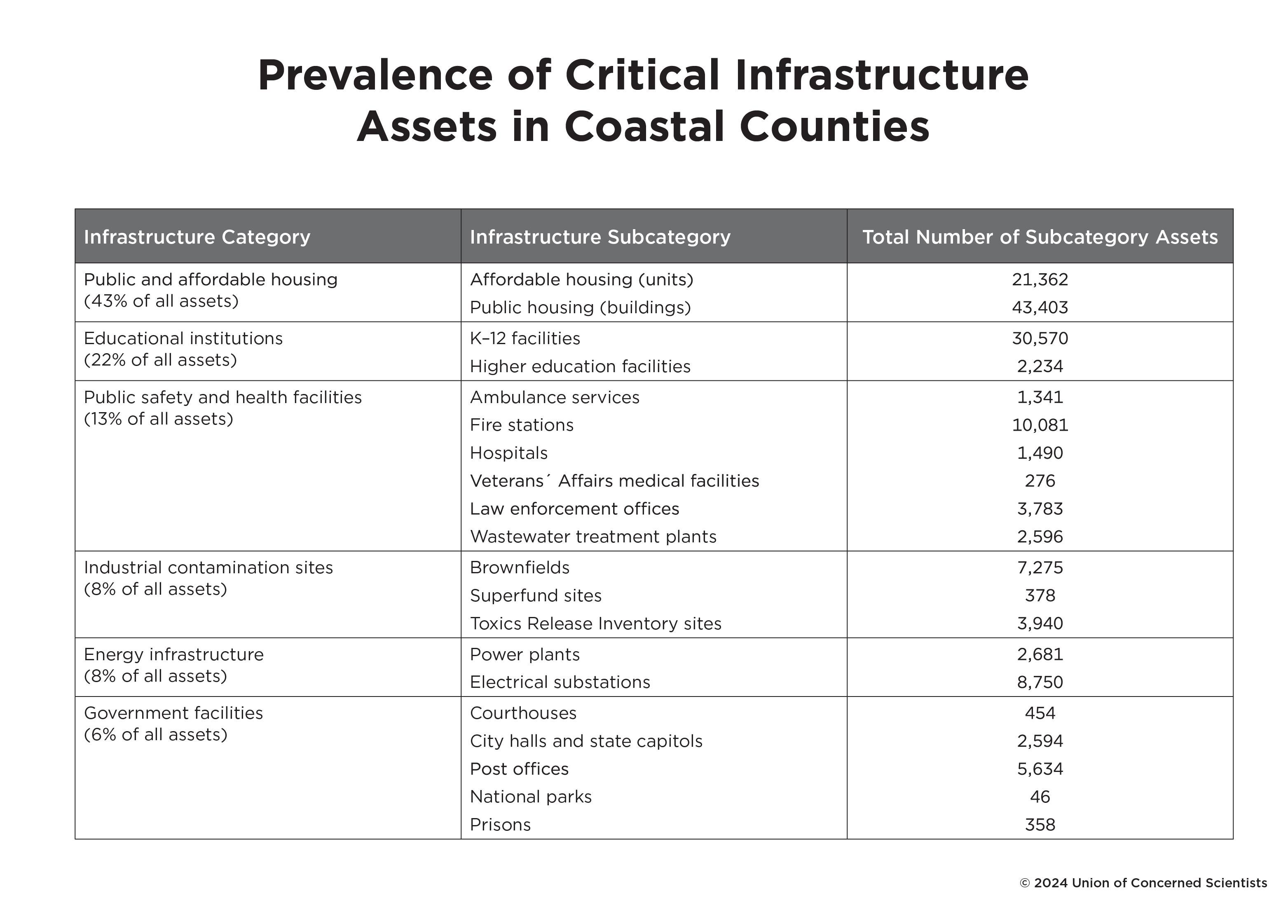
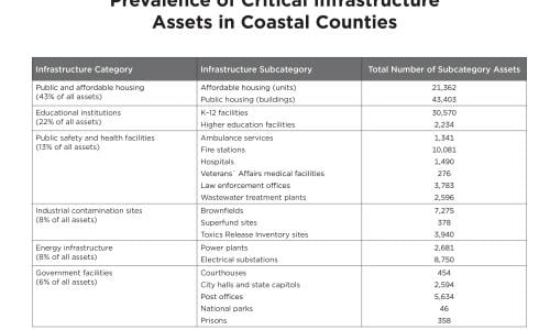
This analysis by the Union of Concerned Scientists (UCS) reveals a significant amount of critical infrastructure at risk today and in the near future, potentially affecting millions of coastal residents. Here we define critical infrastructure as those assets and facilities that provide functions necessary to sustain daily life (CISA, n.d.), which includes schools, hospitals, public and affordable housing, energy infrastructure, and wastewater treatment plants. We also include known sites of industrial contamination that, if they were to flood, could expose people to toxic or hazardous pollutants. The resulting list of critical infrastructure analyzed here is in some instances more expansive than the types included in the US government’s definition but does not include all the types that are likely of concern to individual communities; our selection strives to include infrastructure seen as essential to people's health and well-being for which systemic data were available (see About This Analysis section).
Society highly values the unimpeded functioning of infrastructure assets and the continuous essential services they provide (Weijnen and Correljé 2021). Communities typically—and understandably—have a low tolerance for risk when it comes to these assets (Collini et al. 2022). It is dangerous, then, that so much of our critical infrastructure along the coasts is vulnerable to disruptive flooding in rapidly approaching time frames. Certain regions will be harder hit by this flooding than others, and underserved communities that already carry heavy environmental burdens due to longstanding racial and socioeconomic inequities generally have more infrastructure at risk and fewer resources to address that risk.
The analysis shows that infrastructure in some communities is already exposed to disruptive flooding from high tides. With sea level rise in the coming years, many more communities are running out of time. The picture is bleak: fire stations experiencing monthly flood days; saltwater regularly shorting out the power in entire neighborhoods; thousands of residents of subsidized housing being stranded by high tides; and industrial-polluted water seeping into land and soil and spreading toxins throughout residential areas.
The United States can meet this coming crisis but must act quickly at all levels, through thoughtful decisionmaking by policymakers, planners, and the private sector, and working at the community level to engage residents in designing solutions that will protect or relocate vital buildings and services, preserving their utility for the people who depend on them.
About This Analysis
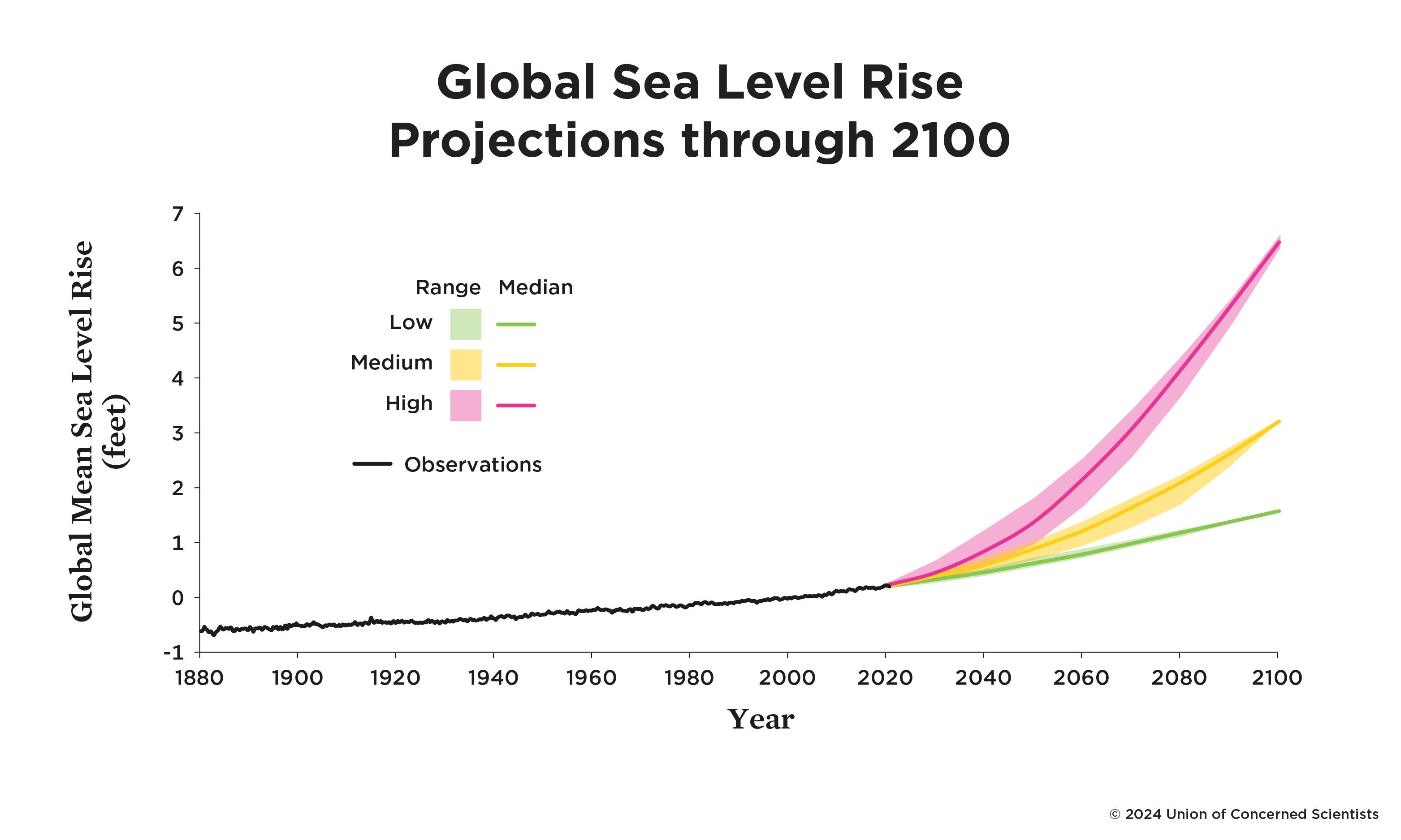
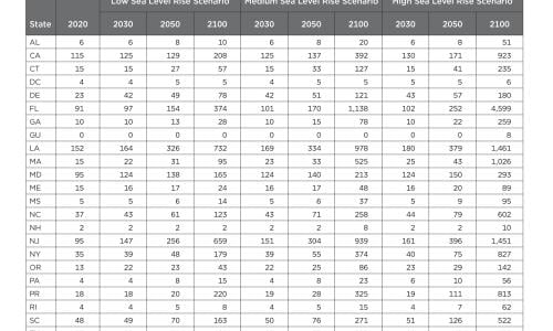
We analyzed the exposure of critical coastal infrastructure through the year 2100 with accelerating sea level rise under three scenarios (Sweet et al. 2022): a low scenario resulting in a global sea level rise of 1.6 feet; a medium scenario resulting in a sea level rise of 3.2 feet; and a high scenario resulting in a sea level rise of 6.5 feet. (See Box 1.) The range of sea level rise among these scenarios, which depends heavily on global heat-trapping emissions, is relatively narrow through midcentury but widens during the second half of the century.
To assess immediate, near-term, and long-term risks, we characterized flooding conditions in 2020, 2030, 2050, and 2100, based on the three future scenarios. For each time period and scenario, we calculated which and how many essential facilities would be flooded 2 (biannually), 12 (on average, monthly), or 26 times (on average, every other week) annually. Throughout this report, we refer to the flooding that occurs with any of these frequencies at any water depth as disruptive flooding. The flooding in our analysis is driven solely by changes in sea level and tidal heights. While not included in the analysis, wave dynamics, storm surge, precipitation, river drainage, and groundwater dynamics can and do contribute to coastal flooding (Mooney et al. 2024).
This analysis includes six categories of critical infrastructure (see Table 1 and Methodology for details). Note that this list is not exhaustive of infrastructure important to communities. Important assets not included here for a variety of reasons are transportation infrastructure, underground spaces (e.g., metro stations), drinking water facilities, and retirement and other care facilities for older adults (Ayyub, Braileanu, and Qureshi 2012; Walker and Ayyub 2022). For more information about how the categories were defined, see the detailed Methodology document at www.ucsusa.org/resources/looming-deadlines-coastal-resilience.
Findings
2020 and 2030: Concerning Numbers of Essential Assets, Buildings, and Services at Risk
Our 2020 results show that roughly 900 critical infrastructure assets nationally are already at risk of disruptive flooding twice per year or more. Public and affordable housing represents the largest category of assets at risk; industrial contamination sites, energy infrastructure, and public safety and health facilities are also highly exposed. In some instances, this potential flooding is being prevented by coastal defenses, such as seawalls, raised buildings, and other flood control measures, that are not well captured in our underlying data. Our current patchwork of coastal defenses and risk mitigation measures, however, is unlikely to completely stave off the more frequent, more extensive inundation to come (Hermans et al. 2023).
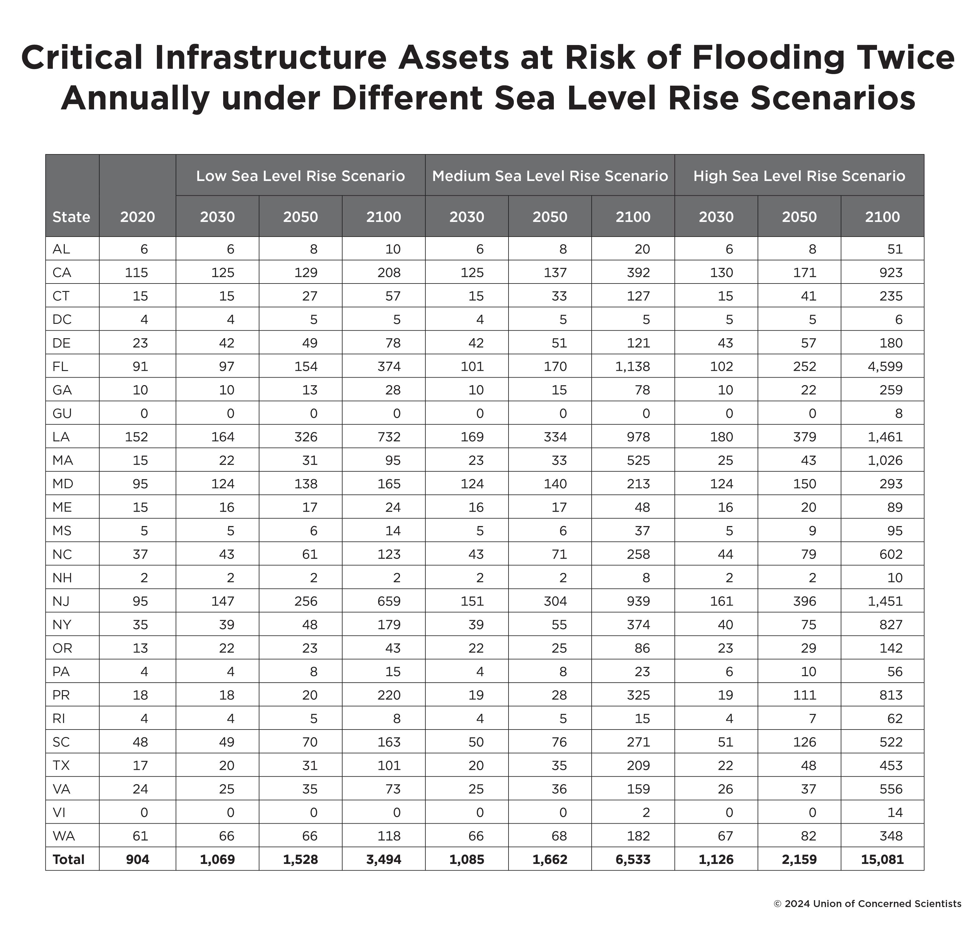
With the medium scenario, our data between 2020 and 2030 show a sharp increase in the amount of infrastructure exposed to two or more disruptive flooding events annually, from 904 assets nationally in 2020 to 1,085 assets nationally in 2030, or a 20 percent increase (see Table 2). This near-term increase in exposure is largely the result of past global carbon emissions, with only minor differences seen across the range of sea level rise scenarios through the end of this decade.
Of the critical infrastructure assets at risk in 2030 under the medium scenario, 717 would be inundated approximately monthly, a 17 percent increase from 2020 conditions. The communities with at-risk infrastructure in 2030 are currently home to nearly 2.2 million people—roughly Houston's population (Census Reporter Profile 2022). Atlantic City, New Jersey, is among the hardest-hit communities in this time frame, with 44 public and affordable housing facilities at risk of flooding twice annually by 2030. Communities in southern Louisiana are also expected to be heavily affected by this time. In the town of Raceland, in Lafourche Parish, 16 public housing buildings, an electrical substation, and a sheriff's office are all in danger of flooding twice annually by the end of this decade.
Of note, communities designated as disadvantaged contain nearly twice twice as many at-risk assets per capita as nondisadvantaged communities. Throughout this report, we define disadvantaged communities as those census tracts designated so by the Climate and Economic Justice Screening Tool (CEJST) developed by the White House Council on Environmental Quality (CEQ 2022). The tool's methodology identifies communities as disadvantaged based on the combination of burdens they face in a number of different categories, including health, housing, and climate change. (See #10 of Assumptions, Limitations, and Caveats and the more detailed Methodology document at www.ucsusa.org/resources/looming-deadlines-coastal-resilience.)
Although we use the CEQ's terminology in our study, we note that this wording—disadvantaged—emphasizes the harms experienced by these communities rather than the systemic nature of injustice or the communities' strengths and assets (Horgan et al. 2024; Sotolongo 2023; Tuck 2009). In addition, an important limitation of the tool's methodology is that it does not consider race, which likely means the tool overlooks some communities that have experienced past and ongoing racism and are undoubtedly disadvantaged as a result. Race data are made available, however, through the CEJST, and we included these in our analysis to examine the racial makeup of communities that the tool identifies as disadvantaged.
Roughly one-third (35 percent) of communities in coastal counties are considered disadvantaged, but they are home to 53 percent of the infrastructure at risk by 2030 under the medium scenario. Additionally, communities in which five or more infrastructure assets are at risk are home to a disproportionately higher percentage of Black residents compared to the national average. Nationally, about 12 percent of people in the United States identify as Black or African American, but in communities with high exposure, Black residents make up, on average, 21 percent of the population.
This greater potential to be affected by flooding is poised to exacerbate existing, unaddressed inequities caused by environmental racism and toxic pollution. These inequities become particularly acute regarding increases in the number of critical infrastructure sites that will be inundated twice per year between 2020 and 2030 in disadvantaged and nondisadvantaged communities. During this decade, our results show a 10 percent increase in public and affordable housing exposed to disruptive flooding twice per year in nondisadvantaged communities but a 40 percent increase in disadvantaged communities. These results may reflect a higher concentration of public housing in disadvantaged communities than in nondisadvantaged communities. During the same period and with the same inundation frequency, the numbers of brownfields and K-12 schools exposed to flooding also increase more rapidly in disadvantaged communities than in those that are nondisadvantaged.
2050: Steep Increase in Amount of Infrastructure Exposed to Flooding
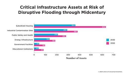
By 2050, substantially more of today's existing critical coastal infrastructure is at risk and many more communities will be coping with the consequences (Figure 2). With the medium scenario, 1,662 critical infrastructure assets are at risk of flooding twice per year by 2050—a near doubling from 2020 exposure and a 53 percent increase relative to 2030 exposure (see Table 2). Of those assets, nearly 1,100 are expected to flood monthly, on average, in this time frame.

Whereas 536 communities are expected to contain inundated infrastructure in 2030, that number jumps to nearly 703 communities by 2050, with Louisiana (334), New Jersey (304), Florida (170), Maryland (140), and California (137) being home to the highest numbers of at-risk coastal infrastructure assets in this time frame. The infrastructure at risk by 2050 serves a population of nearly 2.9 million people today, or nearly the equivalent of the combined populations of Houston and Washington, DC, with communities large and small expected to be affected (Census Reporter Profile 2022). For example, Camden, New Jersey, and San Jose, California, have 24 and 31 critical infrastructure assets at risk of flooding twice annually by 2050, respectively.
Overall, public and affordable housing (507 and 125, respectively), brownfields (189), electrical substations (151), wastewater treatment plants (128), and fire stations (112) are the critical infrastructure types most heavily affected by flooding twice or more annually. To some extent, these numbers reflect the prevalence of each asset subcategory in our underlying dataset. For instance, public and affordable housing represents the largest category of assets in our dataset and the largest category of inundated infrastructure in the analysis. Brownfields, electrical substations, and wastewater treatment plants, however, show a disproportionately high representation among inundated assets compared to the underlying dataset.
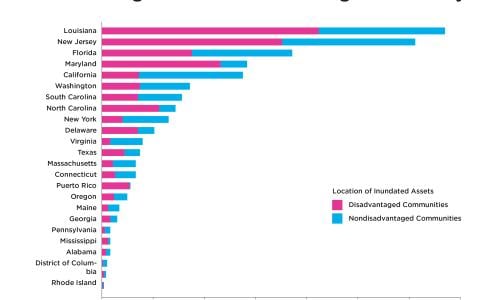
This burden is not shared equitably. Nationally, 54 percent of the critical infrastructure at risk by midcentury is located in disadvantaged communities. In nearly all states, 25 percent or more of the infrastructure at risk is located in disadvantaged communities (Figure 3). On average, disadvantaged communities contain roughly twice as many at-risk infrastructure assets per capita as nondisadvantaged communities, and more than 70 percent of the public housing at risk is located in disadvantaged communities.
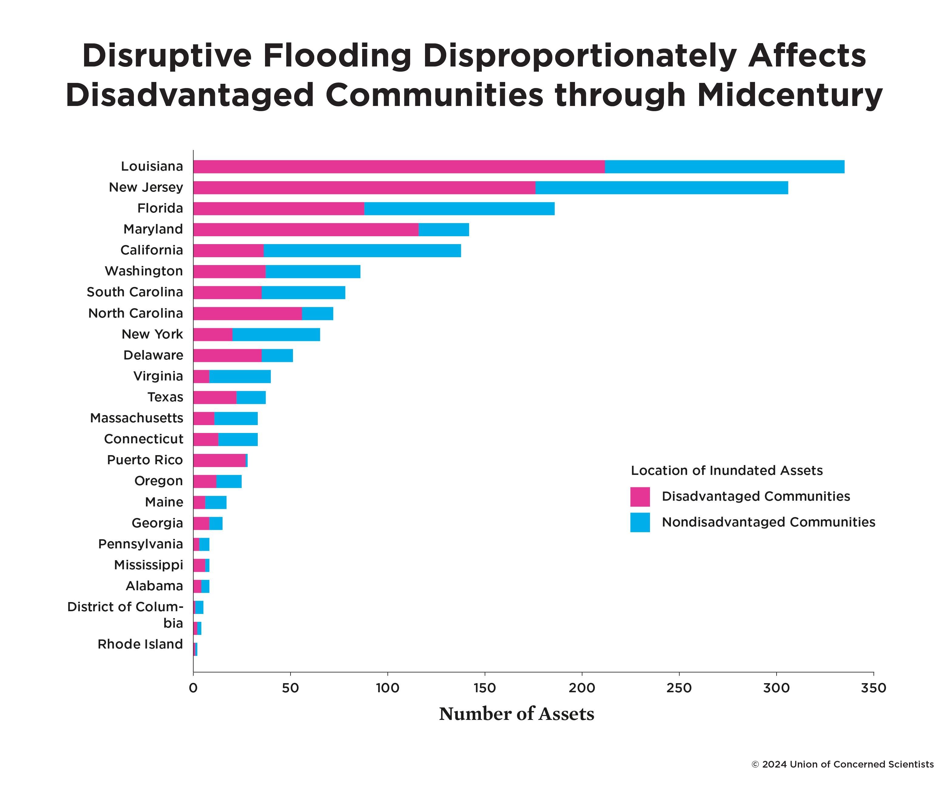
Disadvantaged communities with at-risk infrastructure are home to significantly higher percentages of people who identify as Black or African American, Hispanic or Latino, or Native American than the national average. In some states, these inequities are quite stark. In Maryland, for example, 82 percent of the assets at risk are in disadvantaged communities, where 41 percent of the population identifies as Black or African American, compared to roughly 12 percent of the population nationally and 32 percent of the population in the state (Moslimani et al. 2024; US Census Bureau 2023b). Similarly, in Louisiana, 63 percent of the assets at risk are in disadvantaged communities. On average, the percentage of Native American residents in these Louisiana communities is roughly twice that of the state and national averages (US Census Bureau 2023a).
Often there is more than one type of infrastructure at risk in a community, and the consequences of flooding could intersect. By 2050, nearly 30 assets are at risk of flooding twice annually or more in South Wilmington, Delaware. The at-risk infrastructure in this community, which is designated as disadvantaged, includes brownfields and public housing facilities located in close proximity to one another. Flood events therefore have the potential to spread industrial contaminants throughout neighborhoods with many low-income residents.
Reducing these midcentury risks will require innovative strategies that ensure an influx of investment, retrofitting, and, in some cases, relocating critical infrastructure (see Box 2). Meanwhile, over the next few decades, the design and construction of any new coastal infrastructure must factor in rising seas and other climate impacts. Exactly how disruptive to communities this inundation will be in 2050 depends on our adaptation choices between now and then, including about where and how we construct new coastal infrastructure.
2100: Outcomes for Infrastructure and Communities Depend on Global Heat-Trapping Emissions
The amount of sea level rise between 2050 and 2100, and the rate at which it occurs, largely depends on global emissions of heat-trapping gases over the next several decades and the Earth's physical response to those emissions (Fox-Kemper et al. 2021). For this reason, and because of the long lifetime of infrastructure, our 2100 results from the low and high scenarios represent the plausible range of end-of-century outcomes for today's stock of critical infrastructure or any infrastructure built in its same location. With higher emissions and greater warming, the high scenario becomes more likely and the amount of present-day critical infrastructure exposed to persistent flooding increases, likely with significant disruption to vital services and potentially grave consequences for the continued livability of coastal communities (EPA 2023a; Hauer 2017; Sweet et al. 2022).
Under the low sea level rise scenario, 3,494 critical infrastructure assets flood twice annually—a challenge, to be sure, and a substantial increase from the amount of infrastructure at risk today. Under the medium scenario, 6,533 assets flood with that frequency. And under the high scenario, that figure jumps to 15,081 (see Table 2).
Twice-yearly flooding for a school, public housing building, or wastewater treatment plant would be disruptive and costly. But when we look at greater frequencies of inundation by the end of the century, the data show much worse outcomes, with about 5,300 assets flooding an average of monthly and nearly 4,800 flooding an average of every other week under the medium scenario. Such frequent flooding would likely disrupt essential community services and could expose residents to harmful pollutants.
The low, medium, and high scenarios result in profoundly different implications for the level of adaptation required, for state- and community-level consequences, and for the number of people whose daily lives could be affected. For example, under the high sea level rise scenario, nearly 4,600 essential buildings and facilities in Florida are at risk of disruptive flooding twice annually. Under the medium scenario, less than one-quarter that number (1,138) are at risk. And under the low scenario, less than one-tenth that number (374) are in danger of flooding.
Nationwide, under the high scenario, communities with at-risk infrastructure are home to 13.8 million people—the equivalent of the populations of Houston, Washington, DC, Seattle, New York City, and San Diego combined (Census Reporter Profile 2022). Under the low scenario, however, 4.4 million people are currently living in communities with at-risk infrastructure. While this analysis examined changes only through the year 2100, future global emissions choices will have ramifications for coastal communities around the world far beyond the end of this century (Fox-Kemper et al. 2021).
BOX 1: Sea Level Rise Scenarios and the Use of Medium-Scenario Results
A US interagency task force developed the three scenarios (Figure 1) applied in this study that result in an average of 6.5 feet, 3.2 feet, and 1.6 feet of sea level rise globally by 2100 (Sweet et al. 2022). In task force parlance, these scenarios are high, intermediate, and intermediate-low. We refer to them throughout this report as high, medium, and low, respectively. While each individual scenario has a range of uncertainty, the results described in this analysis refer to each scenario’s mean sea level change.
These scenarios were used to assess changes in flooding frequency based on local characteristics of storminess and tides, including the 18.6-year nodal tidal cycle—a natural cycle that affects tide levels but is not typically incorporated into assessments of future flooding (Thompson et al. 2021). The peak of the nodal tidal cycle amplifies tidal heights, making it an important factor to consider when quantifying future flood risks. Importantly, along US coastlines, a combination of local factors—such as both natural and human-induced land subsidence from hydrocarbon and groundwater extraction—is causing faster-than-global average sea level rise in many places, including Norfolk, Virginia, and Galveston, Texas. By 2100, the two cities would experience increases of 7.2 feet and 8.2 feet, respectively, with the high scenario (NASA Interagency Sea Level Rise Scenario Tool 2022; Yin 2023).
As the planet warms in response to human-caused emissions of heat-trapping gases, land-based ice continues to shrink, adding water to the oceans. Meanwhile, seawater expands, occupying a greater volume. These processes play out over the course of decades to centuries (Sadai et al. 2020; Strauss, Kulp, and Levermann 2015; Strauss et al. 2021) because heat-trapping gases like carbon dioxide remain in the atmosphere for decades and Earth’s ice sheets and oceans are slow to respond to the warming caused by these gases. Even if all heat-trapping emissions worldwide ceased today, the past emissions alone ensure a continued rise in sea levels. Through 2050, relatively little difference exists among the scenarios because much of the sea level rise through midcentury is caused by heat-trapping emissions to date. The major differences emerge in the latter half of the century when the yet undetermined effects of global emissions pathways and ice sheet dynamics influence the extent and rate of sea level rise.
In this report, we focus on the medium sea level rise scenario. While the high scenario could reasonably be used to inform decisionmaking in instances of a low tolerance for risk—such as when examining critical infrastructure that ideally should not be exposed to flooding at all—the amount of sea level rise projected by 2100 under the high scenario is presently thought to have a very low probability of coming to fruition (Collini et al. 2022; Sweet et al. 2022). The amount of sea level rise projected by the high scenario by 2050, however, will occur at some point this century under all the scenarios (Sweet et al. 2022).
Given the interconnected network of assets and services and the long lifetimes expected of critical infrastructure, underinvestment in flood resilience over the course of an asset’s lifetime could be costly. Adaptation measures between now and midcentury that accord with the high scenario will eventually be necessary, which could make such preparatory investments an appropriate and robust near-term risk management strategy. Protection from the risks from storm surge riding on top of higher sea levels is also an important reason to invest in more substantial adaptation measures.
Sea level rise scenarios and projections will inevitably change as the decades progress and as scientific understanding of the likelihood of reaching “tipping points” in ice sheet dynamics evolves. Sea level rise adaptation measures and preparations undertaken during the second half of this century will need to be informed by such considerations as well as by updated projections.
BOX 2: A Voice from the Frontlines
Maureen Holman is more animated discussing the Blue Plains Advanced Wastewater Treatment Plant than some people are about their hobbies or children. As a vice president with DC Water, Holman manages the facility, which is indeed an engineering marvel. It is the largest of its kind in the world, collecting and treating wastewater for 1.6 million residents in the Greater Washington, DC, area.
Holman coordinates projects to ensure the plant’s resilience to climate change, including flooding from sea level rise. “Wastewater plants are absolutely, completely exposed to sea level rise,” she says. “Many were built by design to be gravity-fed, so they’re at the lowest point next to a body of water. If it gets inundated, it can take months to get back online.” And in the meantime, untreated wastewater could pour into the Potomac River and Chesapeake Bay.
Holman and her team understand these risks and have been implementing a long-term plan to protect the wastewater treatment plant—and the people who rely on it to keep their toilets flushing and their sinks draining—with a seawall. To finance the construction of the roughly $30 million project, the plant has received funding through federal grants and other sources. However, no federal or local authority gave Holman explicit guidance to protect against future flooding due to climate change.
“We’re not mandated by any current law to take the measures we’ve taken,” says Holman. “There is no regulation or requirement for wastewater treatment plants to protect themselves from flooding.”
Moreover, many smaller plants do not have the resources to adopt the same protective measures as Blue Plains. And because seawalls and other “hard” solutions to sea level rise can exacerbate problems, such as cause erosion along neighboring stretches of coast that lack such structures, they can be maladaptive (Brucal and Lynham 2021; New et al. 2022). This is the case for thousands of at-risk assets providing essential services that millions of coastal residents depend on. Too often there are insufficient or no requirements to make these buildings flood resilient; there are few resources to help ensure the continuity of services and the environmental well-being of the broader region; and, in some cases, there is no acknowledgment at all that flooding events are already happening and will only increase in frequency and magnitude (Maureen Holman, video interview with Shana Udvardy, April 12, 2024).
Box 3: Focus on Flood Risks to Public and Affordable Housing
For decades, the United States has failed to invest adequately in building and maintaining public and affordable housing (Jones et al. 2023; NAEH, NLIHC, and CBPP 2023).10 This inaction has imposed significant financial, physical, and social hardships on low-income families, especially those in major urban areas where housing tends to be more expensive. Nationwide, there is an estimated shortfall of 7.3 million affordable rental housing units (Aurand et al. 2023), and there has been a sharp rise in homelessness, particularly since pandemic-era income and housing protections, such as eviction moratoria, ended (de Sousa et al. 2023; NAEH, NLIHC, and CBPP 2023). Moreover, past and present racial discrimination has limited access to mortgages and put home ownership (and the generational wealth that accompanies it) out of reach for many Black, Brown, and Indigenous families, leaving them disproportionately harmed by today’s acute affordable housing crisis. Affordable housing is more likely to be older, not as well maintained, and located in areas more prone to climate risks or burdened by pollution (JCHS 2023). Now, flooding from sea level rise is adding an additional challenge by threatening the habitability of existing units and complicating the development of new housing.
Of the infrastructure subcategories included in this analysis, public housing11—which is currently home to approximately 1.6 million12 of the lowest-income people in the United States—has the highest number of assets at risk of disruptive tidal flooding within this decade and beyond, a vulnerability that previous studies have also identified (Buchanan et al. 2020). San Juan, Puerto Rico, New York City, and Boston have some of the highest numbers of such public housing units at risk. Already today, no state has an adequate amount of affordable housing (Aurand et al. 2023), and without protective actions, flooding could put tens of thousands of additional people at risk of losing their homes. Beyond the building structures themselves, flooding can cause cascading infrastructure failures, such as the loss of electricity, which is particularly problematic in high-rise buildings and especially difficult for older residents and residents who require mobility assistance.
In the near-term, to avoid displacing people, policymakers should target investments to areas of greatest need to upgrade existing housing to meet protective flood standards, including elevating and protecting electrical equipment and ensuring backup power sources (Peacock et al. 2015) while also investing in new, climate-resilient affordable housing. The recent rule by the US Department of Housing and Urban Development (HUD) to implement the federal flood risk management standard, which requires the elevation of all HUD-assisted new housing in line with climate science, is an important step forward (HUD 2024). Should buildings flood, it is vital to ensure that residents are not exposed to health hazards from mold, toxics, and other harmful substances. Building owners should maintain adequate flood insurance coverage, recognizing that current Federal Emergency Management Agency (FEMA) flood maps do not account for the risks of accelerating sea level rise. Reforms are needed for current federal disaster aid policies, which are both inadequately funded and primarily geared toward homeowners, often leaving flood-affected renters unprotected (DHRC 2020; Martín et al. 2023; Ortiz et al. 2019). State and federal protections for renters, including against evictions in the wake of disasters, are crucial to increase housing stability for those most marginalized (Martín et al. 2023).
Where possible, investments for both clean energy and climate resilience should be made together to maximize the overall cost-effectiveness of these projects and to best improve residents’ health and decrease their costs (Cohen, McTarnaghan, and Junod 2024). HUD and FEMA offer a number of programs, including some that received funding from the IRA and the IIJA, to help with clean energy, energy efficiency, climate resilience, and disaster recovery improvements for multifamily housing and community resilience measures (Jones et al. 2023). Any building upgrades should also include investments in ensuring accessibility at or above federal civil rights law, as people with disabilities are at significantly higher risk during disasters like flooding, and an estimated 23 percent of households receiving HUD assistance have a member with a disability (Stein et al. 2023; US Census Bureau 2021). Community-wide efforts to lower flood risks can also play an important role in protecting affordable housing. Local decisionmakers must be intentional about preventing climate gentrification (Esson 2024; Tedesco, Keenan, and Hultquist 2022).13 Ensuring meaningful participation of communities and protecting the rights of individuals and communities in the face of potential displacement are essential (HUD 2024; Saadian et al. 2020).
It is clear that the nation must significantly scale up investments in climate-resilient affordable housing and site it outside of the coastal floodplain and, where possible, together with other vital infrastructure, such as mass transit, to foster thriving, safer communities.
Implications and Recommendations
The risks to vital infrastructure and services that millions of people depend on will grow as the global sea level rises in the coming decades, with wide-ranging implications for public health, safety, education, and well-being, and for coastal ecosystems and ways of life. This predicament also creates a profound and urgent responsibility for policymakers and public and private decisionmakers to take protective action now, working together with communities.
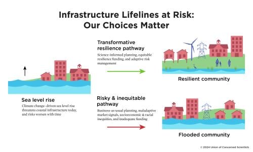
The full range of decisionmakers, planners, and technical experts involved in funding, developing, designing, insuring, operating, and maintaining infrastructure must take immediate steps to safeguard critical infrastructure. They can ensure a more transformative path to true resilience over time, instead of business-as-usual maladaptive choices (see Figure 4). This can be done by implementing science-informed investments, policies, engineering specifications, and changes to market incentives. With sea level rise accelerating and significant infrastructure investments flowing through the Inflation Reduction Act (IRA) and the Infrastructure Investment and Jobs Act (IIJA), the next 10 years afford communities a crucial window in which to make meaningful progress in building climate resilience and safeguard those investments from flooding (Nerem et al. 2018; Spanger-Siegfried et al. 2016; White House 2023; White House 2024). State and federal agencies must also be intentional about not worsening or recreating the nation's history of discrimination and inequitable access to investments for disadvantaged communities (Ganthier et al. 2020).

Recommendation 1: Use science and innovation to plan for near- and long-term risks
Across communities, we have a shared need to assess physical exposure and vulnerability to sea level rise risks and to develop plans to address them. Local and state governments should conduct localized scientific risk and vulnerability assessments of critical infrastructure, including the potential for cascading vulnerabilities of interconnected infrastructure. They should develop comprehensive climate resilience plans—with options, budgets, and resource estimates—to mitigate those risks and build processes to regularly update them with input from all parties involved. Owners and operators of infrastructure, together with engineers and other experts, should develop action plans to address these risks (California Coastal Commission 2021; Rogers Gibson 2017), with public and private resilience planning being appropriately coordinated. An adaptive management approach, in which adaptation strategies are regularly reevaluated based on the latest science and for robustness across plausible future scenarios, will serve best over the near-, medium-, and long-term (New et al. 2022; Wasley et al. 2023).
Scientific projections of sea level rise and coastal flooding should be incorporated into all infrastructure investments, construction, operation, and maintenance. Given the lead time and significant funding needed to plan and construct new critical infrastructure, in most cases, it would be appropriate to plan for a high sea level rise scenario through midcentury (California Coastal Commission 2021). New and improved infrastructure should be designed—and existing infrastructure upgraded—to meet stringent protective flood standards and engineering and building codes that account for rising seas and that remain effective for the assets' expected lifetimes (Walker and Ayyub 2022). In addition to measures onsite, community-wide measures, including beneficial land zoning and protection of natural flood mitigation assets, like wetlands, are extremely valuable and must be prioritized (Urban Ocean Lab 2024). Whenever possible, new critical infrastructure should be sited outside of coastal floodplains, built with the best available, actionable climate science in mind (OSTP 2023), and sited to ensure equitable access to their benefits (ASCE 2023; Ganthier et al. 2020; GAO 2024). Investments in innovative engineering solutions, technologies, and materials can also help defend against or accommodate rising water levels (Ayyub 2023).
To assist communities in adapting to climate change, the Biden administration has released a National Climate Resilience Framework that centers environmental and economic justice and provides opportunities for action (White House 2023). Congress should build on this by enacting a comprehensive national resilience strategy that provides guidance and technical assistance, and helps coordinate and target federal resources for state, regional, and local adaptation efforts (Udvardy 2022). Protecting assets can be expensive and will not be physically possible everywhere, which will necessitate difficult choices, including the potential necessity for managed retreat in some high-risk areas. In these circumstances, communities must have opportunities for meaningful engagement and agency in their choices (EPA 2024; HUD 2024; Moddemeyer et al. 2022; see also recommendation #3).
Recommendation 2: Scale up public and private sector funding for infrastructure resilience
Despite its importance, US infrastructure has long been woefully underfunded and routinely assessed as requiring attention (ASCE 2021; McBride, Berman, and Siripurapu 2023), and sea level rise exposes and exacerbates those vulnerabilities (Thorp, McConnell, and Siders 2023). Public and private investments in infrastructure resilience must be scaled up across the board (Coffee et al. 2022; Moser, Coffee, and Seville 2017; Wasley et al. 2023). And data from the National Institute of Building Sciences show that investing in retrofitting "lifelines" (Pressly 2014) such as wastewater facilities and electric substations has a benefit-cost ratio as high as 31 to 1 (NIBS 2020). Given the need for the safety and reliability of critical infrastructure, utilities and regulators should adopt a risk-averse approach to manage flooding driven by accelerating sea level rise (Ayyub et al. 2024; Haine 2015).
State and federal policymakers must marshal funding for the proactive protection of infrastructure and prioritize resources for less wealthy and historically disadvantaged communities. Although existing federal funding is helpful, it falls well short of what is required and must be better aligned with projections of future flood risks (GAO 2024). Congress should also consider public-private opportunities, such as through a national resilient infrastructure bank (100RC 2018). Funding raised through taxes, fees, utility rates, municipal bonds, and loans will all likely need to play a role, given the scale of the challenge (City of Miami, n.d.; Coffee et al. 2022; MTC 2023; Plastrik, Coffee, and Cleveland 2019). Litigation pathways could help make polluters fund climate resilience in addition to paying their share for damages, as part of holding fossil fuel companies accountable for their outsize role in the climate crisis (Dedina 2017; Merner 2023). All incentives should address and engage with the important role of local land use planning and development choices, which today are a significant driver of heat-trapping emissions and the increased need for infrastructure investment (Feng and Gauthier 2021; SGA and T4A 2020).
Many critical infrastructure assets, including those in the power and wastewater management sectors, are owned, operated, or managed by private sector entities, which makes their role essential in planning for and investing in climate resilience measures. For example, since Hurricane Sandy, New York City energy provider Con Edison (2023) has invested $1.1 billion in the implementation of climate resilience plans and design standards for its assets. Public utility commissions should require that utilities account for climate risks and make prudent investments in resilience while safeguarding the interests of ratepayers and protecting low-income households from potential rate spikes related to adaptation investments. Utilities—both private and public—and energy regulators should prioritize holistic approaches that include more distributed and resilient power systems that integrate energy efficiency, renewable electricity, and energy storage (McNamara et al. 2015).
Market signals and incentives must be science-informed to prevent maladaptive choices and promote resilient outcomes. For instance, current flood insurance rates—whether through the National Flood Insurance Program or private insurance—do not reflect projections of growing flood risks along our coastline and thus subsidize continued development in harm's way (Weber 2024). At the same time, sharp increases in insurance rates without any affordability provisions could leave low-income residents without coverage. Repeatedly flooded communities may also be at risk of a lowered credit rating, which can make it more challenging to raise bond funding or secure low-cost loans for resilience investments. Ensuring that resilience resources are equitably distributed and that market-driven changes do not contribute to the displacement of lower-income residents, or "climate gentrification"—a term coined by community advocate Paulette Richards—will require intentional federal, state, and local policies (Esson 2024; Keenan, Hill, and Gumber 2018; Richards 2020).
Recommendation 3: Reduce historical inequities and prevent future harms
Our results show that communities already disadvantaged by historical and present racism, poverty, and other factors face a disproportionate burden of the nation's current and future risks to coastal infrastructure. In some cases, these communities are in particularly flood-prone areas because economic factors, colonialism, racism, and deliberate policies, such as mortgage redlining, denied them access to, dispossessed them of, or forcibly moved them from more desirable areas on higher ground (Caldas et al. 2023). Often, these same communities have also borne the health impacts of polluting and risky infrastructure intentionally sited in or near them, such as Superfund and other toxic or hazardous contamination sites (Kiaghadi, Rifai, and Dawson 2021; Taylor 2022). Worsening coastal flood risks add an additional layer of risk and compound harm.
In this context, it is safe to assume that communities would be highly risk averse to the probability of additional harmful outcomes (Ayyub et al. 2024; OMB 2023). Policymakers and decisionmakers should undertake resilience investments that limit further burdening these communities; ensure that historically disadvantaged communities are prioritized for resources, including through effective implementation of the Justice40 Initiative; reduce barriers to funding and resources; reflect risk aversion through Office of Management and Budget guidance; and enable better outcomes. Communities should also have a direct say in the decisions that affect them, and policymakers must respect Tribal sovereignty (Caldas et al. 2023).
From Crisfield, Maryland, to Terrebonne Parish, Louisiana, the challenge of coastal flooding is already a reality for many smaller, low-income communities along the US East and Gulf coasts that simply do not have the resources to invest in adaptation planning. It must be a national imperative to provide resources, data, and technical assistance for local resilience planning so communities can understand and evaluate their choices (PolicyLink 2020). Decisionmakers must ensure that harmful histories of racism and inequities are not repeated as we invest in upgrading and building new climate-resilient infrastructure.
Recommendation 4: Protect affordable housing; open just pathways to retreat
Public and affordable housing represents the single most at-risk category of infrastructure assets evaluated in this analysis. Any loss of these units will add to the already acute crisis in the availability of such housing, driven by decades of underinvestment and racial discrimination that puts many families at risk of being without housing today. Repeated flooding can also cause structural problems, mold, and other hazards to residents if buildings continue to be used. All levels of government must invest in the protection, renovation, and construction of climate-resilient and energy-efficient affordable housing (see Box 3).
In places most highly exposed to flood risks, multiple critical infrastructure assets as well as homes and businesses may be in jeopardy, making the task of protecting them all eventually untenable. In such cases, decisionmakers may need to initiate hard conversations about managed retreat of entire communities. These discussions should include both resettlement resources for displaced communities and resources and infrastructure investments for receiving communities. Communities may also prefer to invest in land trusts on safer ground where they could move together, and federal funding for such investments could be set aside for historically disadvantaged communities. All these decisions must take place within a broader institutional framework that provides for meaningful engagement with communities (HUD 2024). Importantly, a human rights--centered approach must be embedded in policies and governance related to displacement (Henneberger 2015; OCHA 2004; Saadian et al. 2020).
Recommendation 5: Start informed, flexible, adaptive planning now for later-century potential outcomes
Both the emissions choices we make over the next several decades and ice sheet dynamics will have significant bearing on the magnitude of the threat sea level rise poses to coastal infrastructure in the long term. For this reason, it is important to embark on adaptation pathways that enable future flexibility. Adaptive design of engineering projects and buildings can help ensure they reliably function over their full lifetime—with the potential to be upgraded as needed—taking into account the plausible range of climate futures (AIA 2021; Ayyub 2018).
Longer-term planning should include a range of scenarios for sea level rise and options for solutions that are robust and give communities opportunities to make choices over time. Communities will need to weigh whether the optimal choice is to make a limited investment in protecting an asset at risk in the near term while using the time gained to relocate the services it provides—or the community more broadly—to higher ground. In some cases, elevating or walling off assets may provide a time-limited way to protect them, though eventually relocating them may be the only viable option.
Scenario planning at the local level will need to incorporate the potential for compound and cascading risks, given the network of interdependencies in many kinds of essential infrastructure (Mach et al. 2023), as well as consider the cumulative health and environmental risks to communities from infrastructure failures. Technical assistance, resources, and funding from federal and state governments will be crucial for advancing these efforts. This aid could include help with establishing a rating system and metrics for climate-resilient infrastructure to help planners advance design criteria to ensure projects can deliver multiple benefits over their full lifetime (100RC 2018).
Recommendation 6: Cut heat-trapping emissions to limit the pace and magnitude of sea level rise
Sharply curtailing global heat-trapping emissions and phasing out fossil fuels while ramping up clean energy solutions must also be a cornerstone of our work to enable resilience on our coastlines. While near-term sea level rise is largely locked in, the choices nations make about the global emissions pathway, starting right now, could lead to profoundly different levels of risk on our coastlines over the course of the century.
As a relatively wealthy nation and the leading contributor to historical heat-trapping emissions, the United States has a unique responsibility to contribute to global climate efforts. A recent UCS study found that the United States can meet its climate targets, but it will require significant new policies and investments (Clemmer et al. 2023). Transformative changes to enable a rapid clean energy transition will also deliver tremendous economic, health, and climate benefits to the nation—including more than $800 billion in annual public health savings and nearly $1.3 trillion in avoided climate damages by 2050. Reports from the Intergovernmental Panel on Climate Change (Shukla et al. 2023) and the International Energy Agency (IEA 2023) reach similar conclusions at the global level. Decisionmakers at local, state, federal, and international levels must prioritize a rapid and equitable transition to clean, affordable energy while ensuring a phaseout of fossil fuels.
Conclusion
There is a narrow window of time for federal, state, and local policymakers to provide funding and resources and for local decisionmakers to use this backing to implement changes in their communities in preparation for an inevitable increase of regular disruptive flooding. And while our analysis shows that the scale of the challenge is daunting, it also points to actionable, science-informed steps that can and must be taken to protect vital infrastructure and services. Policymakers and decisionmakers at all levels of government, in communities, and in the private sector must quickly step up and make these forward-looking decisions. Investments in resilience, equitably shared, can help build a safer, fairer future for all.
Methodology
This analysis followed a published methodology (Dahl et al. 2017), and used tide gauge data, sea level rise projections, digital elevation models (DEMs; NOAA Sea Level Rise Data Download 2024), and asset-level infrastructure data to identify assets at risk of current and future flooding. We combined localized sea level rise projections (Sweet et al. 2022) at tidal stations along US coastlines with an analysis of local storminess and tides to assess changes in flooding frequency that include the 18.6-year nodal tidal cycle (Thompson et al. 2021). Data from each station were used to identify water heights reached or exceeded 2, 12, or 26 times per year. We then added projected sea level rise to those heights and compared the result to the DEMs (NOAA Office for Coastal Management 2017). This yielded maps of areas flooded 2, 12, or 26 times per year under each sea level rise scenario. We define disruptive flooding as flooding that occurs at least twice per year.
These maps were then intersected with geospatially referenced infrastructure data compiled from the USGS National Structures Dataset (USGS 2024), HUD Public Housing Buildings (2024), the Environmental Protection Agency (EPA NPL Superfund Site Boundaries 2024; EPA TRI Basic Data Files 2023; EPA Geospatial Data Download 2021), US Energy Information Administration (EIA Electricity 2023), Homeland Infrastructure Found-Level Data (HIFLD 2024), National Housing Preservation Database (2023), and National Oceanic and Atmospheric Administration (NOAA Electric Power Substations 2017). Finally, we analyzed the population potentially affected by inundated infrastructure using the White House CEQ Climate and Economic Justice Screening Tool (2022) and the data therein. A more detailed methodology for this report can be found at www.ucsusa.org/resources/looming-deadlines-coastal-resilience.
Assumptions, Limitations, and Caveats
-
The flood extents we identify depend on the quality of the underlying DEMs. Where possible, communities should do more detailed mapping using the highest-resolution DEMs available.
-
The DEMs used here do not capture all coastal defense structures. Areas with such structures may not experience as much flooding as suggested by our analysis. Any structures developed after the DEMs were created are not reflected.
-
We excluded infrastructure protected by federal levees or designated as having reduced flood risk (FEMA 2024; NOAA Sea Level Rise Viewer 2024; USACE National Levee Database 2024), assuming such infrastructure will be protected. If these systems fail or are damaged, that infrastructure could flood.
-
Coastal morphology can attenuate or amplify tide and surge relative to their levels at the ocean-facing tide gauges we employed. As a result, some areas may experience greater or lesser flooding than we estimate.
-
We make no assumptions about future community-level adaptation measures.
-
Population, demographics, and the location and number of infrastructure assets are assumed to be constant at present-day levels. This could make our estimates conservative (Hauer 2017).
-
We did not systematically and independently verify the locations or current uses of infrastructure assets, nor did we assess ground-floor elevations.
-
This analysis does not distinguish between the mechanisms (e.g., high tides, storm surge, swash, and wave run-up) that could cause flooding.
-
Improved estimates of coastal subsidence rates or increased future subsidence rates would change the exposure of critical infrastructure to disruptive flooding (Ohenhen et al. 2024).
-
The screening tool we used to identify disadvantaged communities (CEQ 2022) has limitations (WHEJAC 2021). Some communities that are undoubtedly disadvantaged may be excluded by the tool.
Authors
Kristina Dahl is the principal climate scientist in the UCS Climate and Energy Program. Juan Declet-Barreto is the senior social scientist for climate vulnerability in the program. Rachel Cleetus is the policy director in the program. Erika Spanger is the director of strategic climate analytics in the program. Benjamin Vitale is an independent software engineer. Shana Udvardy is the senior climate resilience policy analyst in the UCS Climate and Energy Program. Philip Thompson is an associate professor at the University of Hawai`i--Manoa (UH) and director of the UH Sea Level Center. Pamela Worth is the senior writing manager at UCS. Astrid Caldas is the senior climate scientist for community resilience in the UCS Climate and Energy Program.
Acknowledgments
This report was made possible by the generous support of the Barr Foundation, the Farvue Foundation, the Grantham Foundation for the Protection of the Environment, the Scherman Foundation, and UCS members.
The report authors thank Andrew Aurand, National Low Income Housing Coalition; Bilal Ayyub, University of Maryland; Mark Merrifield, Scripps Institute of Oceanography; Noah Patton, National Low Income Housing Coalition, and Manuel Salgado, WE ACT, for their invaluable advice and reviews of this report. The report also benefited from the reviews and advice of many people within UCS, including Kate Cell, Jeff Deyette, Amanda Fencl, Paula García, Chitra Kumar, Adam Markham, Zoe Middleton, Alicia Race, Maegan Ramirez, and Ashley Siefert Nunes. William Brooks, Doug Marcy, and William Sweet of NOAA provided technical guidance. The authors also thank Maureen Holman for sharing her perspective and Annika Vawter for her work on an early version of this analysis. Finally, we thank Dana Johnson, Tyler Kemp-Benedict, Heather Tuttle, and Bryan Wadsworth for editing and publication support.
Organizational affiliations are listed for identification purposes only. The opinions expressed herein do not necessarily reflect those of the organizations that funded the work or the individuals who informed or reviewed it. The Union of Concerned Scientists bears sole responsibility for the report's content.
This is an online version of the report. For the full text, please download the PDF.
In this report

Looming Deadlines interactive map

¿Por qué sube el nivel del mar?
Looming Deadlines for Coastal Resilience Series
Prevalence of Critical Infrastructure in Coastal Counties

Global Sea Level Rise Projected through 2100
Choices Matter for Infrastructure at Risk
Disproportionate Effects of Flooding on Disadvantaged Communities
Flood Risk for Infrastructure Assets under Different Sea Level Rise Scenarios
2100, resulting in consequentially different levels of infrastructure exposure.
Infrastructure Assets at Risk of Flooding through Midcentury
Downloads
Citation
Dahl, Kristina, Juan Declet-Barreto, Rachel Cleetus, Erika Spanger, Benjamin Vitale, Shana Udvardy, Philip Thompson, Pamela Worth, and Astrid Caldas. 2024. Looming Deadlines for Coastal Resilience: Rising Seas, Disruptive Tides, and Risks to Coastal Infrastructure. Cambridge, MA: Union of Concerned Scientists. https://www.ucsusa.org/resources/looming-deadlines-coastal-resilience. https://doi.org/10.47923/2024.15502
Related resources
Applications of Climate, Energy, and Environmental Justice
Environmental, Climate, and Energy Justice—What Do They Mean?

Science and Environmental Justice