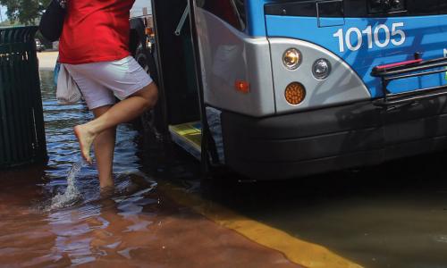
Norfolk, Virginia’s second-largest city, is home to nearly 250,000 people as well as the world’s largest naval base. One of nine cities and seven counties in the Hampton Roads metropolitan area, Norfolk sits between the Elizabeth River and Chesapeake Bay. Surrounded by water on three sides and lacking high ground, residents know what it is like to live with flooding. Some neighborhoods have permanent road signs warning of flooding. And, as in other communities along the mid-Atlantic coast, locals are starting to use social media as a flood-warning system, and to gather more information on the extent of flooding.
The city is vulnerable to flooding when tides combine with heavy rain, and when nor’easters and hurricanes bring storm surge ashore. However, Norfolk residents are increasingly grappling with floods caused by the more frequent and subtle occurrence of high tides combined with a slowly rising sea.
Sea level has been rising along the mid-Atlantic coast at about three times the global pace. At places along the Hampton Roads coastline, it has risen by more than a foot over the past 80 years. As the sea encroaches on Norfolk, the city’s experience paints an informative picture of what is in store for many other East Coast cities.
Encroaching Tides
This profile is excerpted from the 2014 report, "Encroaching Tides: How Sea Level Rise and Tidal Flooding Threaten U.S. East and Gulf Coast Communities over the next 30 Years."
Diligent residents track the tides and move their cars to higher ground during full moons—sometimes streets away from where they live—and many sidestep salty puddles to get to their homes and businesses. When tides are at their most extreme, some streets become impassable from floodwater. And waterfront parks are becoming too soggy and salty for grass to grow.
To address chronic flooding, the city is restoring wetlands, essentially allowing the sea to reclaim these areas. Richmond Crescent—waterfront parkland north of downtown—has become a wetland, and the city has built pools to absorb both tidal flooding and stormwater runoff. Today an extensive road and tunnel network linking the city to the surrounding area usually closes only during heavy rain events and other storms. However, few alternate routes are available, requiring lengthy detours. Flooding of tunnels and approaches to bridges hinders safe evacuation and emergency services, and shelter options in such a low-lying area are limited. Continued sea level rise will only compound these problems. As James Redick, director of the city’s Department of Emergency Preparedness and Response, says: “As sea levels rise, the areas that need to be evacuated increase, and the space for sheltering shrinks.”
The number of flooding events in Norfolk each year has tripled since the 1970s, and tidal flooding now occurs about once a month. Sea level at Norfolk is projected to rise at least six inches by 2030. By then the city could see almost 40 tidal flooding events per year—about a quadrupling compared with today. Facing such frequent flooding, the city would likely continue to lose coastal parks to wetlands or otherwise cede them to the sea.
What that would mean for flood-prone neighborhoods depends on residents’ tolerance for repeated disruption and on the policies put in place to assist them. Tidal flooding has already made it more difficult for some residents to sell their homes and driven declining home values in neighborhoods key to the city’s tax revenues.
In 30 years’ time—the duration of a typical mortgage—the city could see 180 floods a year from regular high tides. Higher seas would also allow high tides to penetrate farther inland, affecting many more people and places in the metropolitan area, home to 1.5 million people.
Taking action
One of the first U.S. cities to plan for sea level rise, Norfolk is considering large-scale, citywide measures to protect residents and critical infrastructure. The city already requires developers to raise new buildings three feet above the 100-year flood level. And Fugro Atlantic, a Dutch energy infrastructure firm, has recommended a suite of options such as floodwalls, tide gates, elevated roads, and pumping stations, at a cost of at least $1 billion.
With almost 30,000 workers employed at the naval shipyard, access is crucial if the naval station is to continue to operate, and its leaders are working with the community to cope with future sea level rise. For example, the station is replacing some of its 14 piers—at a cost of $60 million each—to make them less vulnerable to tidal and storm-induced flooding.
Like other places in Virginia, Norfolk has received limited guidance from the state, which only recently set up a Climate Change Commission. But as the Department of Defense (DOD), a major source of funding in Virginia, and other federal agencies begin to view sea level rise as a security risk, there are signs of change at the state level. The governor has created a Task Force on Climate Resilience, a Recurrent Coastal Flooding Subpanel, and a pilot project to coordinate efforts between the DOD and local, state, other federal, and industry officials.
Norfolk Mayor Paul Fraim reports that flooding now occurs monthly, and the city has joined the Rockefeller 100 Resilient Cities Challenge, a program that encourages cities around the world to become more resilient in the face of physical, social, and economic challenges this century. But despite Norfolk’s efforts to tackle the impacts of sea level rise, the mayor has acknowledged that residents might need to eventually retreat from areas that flood repeatedly owing to both tides and rain.
As more and more U.S. cities face regular tidal flooding, they will be looking to Norfolk as a community seasoned in the hard work of persisting amid encroaching seas.
Related resources

2024 Annual Report
Inside Multnomah County's Climate Lawsuit

A Path Forward