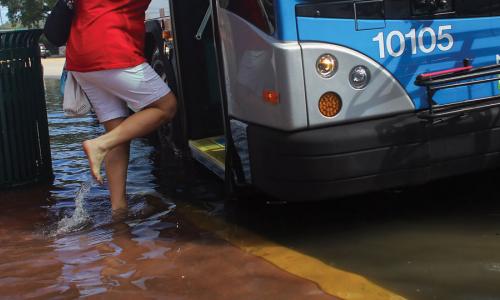
As they wind their way toward Chesapeake Bay, the Potomac and Anacostia Rivers define the borders of Washington, DC, and the many historic landmarks nearby, from Arlington National Cemetery to Old Town Alexandria, VA. Tides affect these rivers, and tidal flooding can produce effects ranging from patches of standing water in parks to flooded roadways.
This profile is excerpted from the 2014 report, "Encroaching Tides: How Sea Level Rise and Tidal Flooding Threaten U.S. East and Gulf Coast Communities over the next 30 Years."
Encroaching Tides
By 2045, Washington is projected to lead the East Coast in the number of tidal floods each year: it can expect nearly 400. These chronic floods will also be more extensive than the typical tidal floods today. Leaders of the nation’s capital have outfitted one of its assets—Washington Harbour—with a seawall to protect the area from flooding. Officials in nearby Alexandria are also considering options for mitigating today’s flooding problems, including installing flood barriers and raising roadways.
Related resources

Sea level rise, explained by kids

Science Hub for Climate Litigation

Research Areas for Climate Litigation