On the South Jersey Shore, Atlantic City and neighboring coastal and island towns such as Ventnor, Brigantine, and Ocean City are not only rebuilding after Hurricane Sandy but also grappling with how to prepare for rising seas. The region—a low-lying chain of barrier islands and back-bay estuaries—is vulnerable. Atlantic City, a major resort renowned for its boardwalk, beaches, and casinos, has put revitalizing the arts and city parks high on its agenda, while other less-resourced areas struggle just to recover from the 2012 storm.
With some of the highest unemployment and poverty rates in the region, segments of the Atlantic City community are particularly vulnerable to the impacts of coastal inundation. Some older neighborhoods that are home to the most socially vulnerable residents flood regularly during a full or new moon, or if winds and high tides combine to push water against the shore. When the wind blows onshore during storms, water does not drain out of the bays, raising water levels even higher during high tide and complicating daily life.
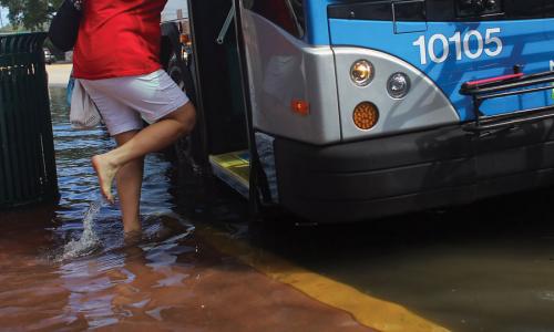
Tidal flooding now occurs 30 times a year in the region, on average. Such floods typically make the news when a nor’easter bottles up the water in the back bays, but more isolated flooding occurs far more often. In barrier island towns from Ventnor to Beach Haven, and on the mainland from Egg Harbor Township to Little Egg Harbor Township, road closures complicate commutes to work and school. When a high tide is predicted, residents may move their cars to avoid corrosion and the need to wade.
Bridges and causeways—crucial links from the coast to inland areas—are especially vulnerable to closure. The Blackhorse Pike, linking West Atlantic City to the mainland—closes about once a month. After a strong nor’easter in early January 2014, for example, the most flood-prone areas were under more than a foot and a half of water, and many roads closed for several hours. Tidal flooding can also lead to backflow from the stormwater system in many towns, because water cannot drain to the sea.
Since the 1970s, the frequency of tidal floods in Atlantic City has grown fivefold. Sea level along the mid-Atlantic coast is now rising at more than three times the global pace—partly because the land is sinking. Over the last 100 years, sea level has risen more than 15 inches at Atlantic City, contributing to the area’s flooding problems.
Encroaching Tides
In Atlantic City, flooding is becoming so common that the National Weather Service raised the water level at which it issues coastal flood advisories by more than three inches, to avoid causing public fatigue with such alerts. That means that even as tidal flooding occurs more often, the public will receive fewer advisories.
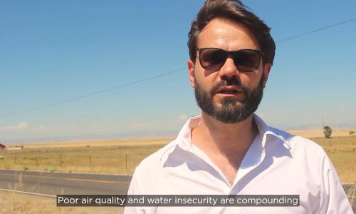
This profile is excerpted from the 2014 report, Encroaching Tides: How Sea Level Rise and Tidal Flooding Threaten U.S. East and Gulf Coast Communities over the next 30 Years."
If the closures of roads and bridges are now a periodic annoyance, they are expected to be a regular occurrence in just 15 years’ time. As sea level rises, the frequency of tidal floods could more than triple in the Atlantic City area—occurring 90 times a year. This means that, on average, tidal flood conditions would beset communities twice each month over a roughly four-day period. Flooded communities would face constant road and bridge closures and saltwater damage to property, without substantial changes to infrastructure. And when high tide coincides with wind or rain, weather systems far less powerful than Hurricane Sandy could cause substantial damage.
The picture for 2045 is even more serious. Based on a mid-range estimate of slightly more than a foot of sea level rise by 2045, the Atlantic City area can expect more than 240 floods annually. And because sea level will be higher, more floods will be extensive, posing greater risks to people and property. Such unrelenting disruption could radically change the South Jersey Shore as a place to live and play.
Taking action
After Hurricane Sandy, Atlantic City received federal funding to build a several-mile-long seawall to protect parts of the city from severe flooding and storm surge. The state is also beginning to act. New Jersey’s new Hazard Management Plan suggests how to minimize risk to both natural and built systems. And Governor Christie’s administration is helping 14 counties update their hazard mitigation plans with $3 million in aid. Communities are also beginning to recognize sea level rise as a growing problem. Ocean County, for example, has produced New Jersey’s first county hazard mitigation plan that highlights sea level rise.
Many flood-prone areas of the South Jersey Shore are heavily developed. In the near term, houses and roads may need to be elevated to be kept safe and usable, and in the long term even relocated. Communities faced with incessant tidal flooding may eventually need to draw back from parts of the shore. Sea level is rising, and this low-lying area is highly vulnerable. Residents and leaders have hard work ahead to build the resilience of the South Jersey Shore.
Related resources

Sea level rise, explained by kids

Science Hub for Climate Litigation

Research Areas for Climate Litigation