Spanning the shoreline of the populous boroughs of Queens and Brooklyn in New York, Jamaica Bay’s salt marshes provide habitat for fish and birdlife amid one of the world’s largest cities. The narrow Rockaway Inlet, which links the bay to the Atlantic Ocean, funnels tides and storm surges into the bay with some force.
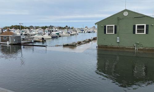
Hurricane Sandy had a devastating effect on communities along the bay, including the Rockaways, Howard Beach, Broad Channel, Sheepshead Bay, and Mill Basin, causing major flooding. Rebuilding continues, but scars on the landscape may be visible for years to come. Though a far gentler force, regular high tides also pose flooding problems for residents of these same beleaguered areas, because of their low elevation and rising seas.
Jamaica Bay is part of the Gateway National Recreation Area, a unique natural environment within a highly urbanized setting, an important waypoint for migratory birds, and a place of significant historic and cultural heritage. This is the only wildlife refuge in the country accessible by subway. But dredging, shoreline bulkheads (barriers), sea level rise, and sewage runoff have led to major erosion of the bay’s marshes and islands.
The area once had rich shellfisheries, and the Rockaways were a popular summer resort destination. Today, mostly working-class neighborhoods enjoy spectacular water views, but must contend with frequently flooded streets and sidewalks during high tides and heavy rainfall, and worse impacts during larger storms.
This profile is excerpted from the 2014 report, "Encroaching Tides: How Sea Level Rise and Tidal Flooding Threaten U.S. East and Gulf Coast Communities over the next 30 Years."
Encroaching Tides
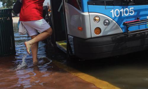
Because drainage infrastructure is aging, flooding today sometimes causes combined sewage and stormwater to overflow into streets. Standing water provides a breeding spot for mosquitoes, and vehicles caught in the water can be damaged. Major floods—such as those during Hurricane Irene in 2011, which coincided with a new moon—can bring several feet of inundation, cutting off entire neighborhoods, flooding basements, and damaging property.
FEMA flood-risk maps released in 2013 show that most of the Rockaways and Broad Channel neighborhoods—which have much higher poverty rates than Howard Beach—are already high-flood-risk zones. With further sea level rise, flood risks are expected to grow.
Over the last century, the water level in Jamaica Bay (as measured at the nearby Battery tide gauge) has risen nearly a foot, owing to both sea level rise and local subsidence of the land. Minor flooding events in the Broad Channel area now occur once or twice a month, or more. And our analysis shows that continued sea level rise means that the frequency of flooding events in Jamaica Bay will triple by 2030, and increase nearly 10-fold by 2045, compared with today.
Dan Mundy, Sr., former president of the Broad Channel Civic Association and a retired captain in the New York City Fire Department, knows that flooding is becoming worse. “Every home in Broad Channel has a calendar with the lunar cycle and tide predictions clearly marked for each day of the year,” he says. “We live by the tidal cycles here: flooding is becoming more common, and much more of an inconvenience than ever before.” Volunteer firefighters at the Broad Channel Fire Department know which streets might need evacuation by inflatable boats.
Locals also know to keep an eye on the winds. Even a slight east or northeast wind with a high tide can cause areas in Broad Channel to flood. In Jamaica Bay, high tides during a full moon occur once a month near 8:00 a.m.—about the time families are trying to commute to work and school. In some areas residents move their cars the night before—particularly if wind is forecast—or both they and their cars can be stranded. Importantly, there is no NOAA tide gauge in Jamaica Bay itself. The nearest gauge, used as a proxy in this analysis, is located at The Battery in New York City, and sees far less flooding than communities like Broad Channel. On days like September 12, 2014, Broad Channel can experience significant tidal flooding though no coastal flood advisory for the broader area is issued.
Taking action
The Broad Channel community is a proactive one. After more than a decade of lobbying by the Broad Channel Civic Association, the City of New York has funded and begun work on a $23 million project to enable West 11th, 12th, and 13th Streets to withstand and avoid flooding. The project entails elevating roads, installing a new sewer system and water mains, building a special drainage system to the bay, and instituting a novel shared-streets approach, wherein pedestrians and vehicles occupy a single one-lane road together—the first of its kind in the state.
Hurricane Sandy exposed key vulnerabilities that will increase with continued sea level rise. A Stronger, More Resilient New York—a 2013 report spearheaded by former Mayor Michael Bloomberg—outlines plans to improve the city’s ability to cope with climate change and future storms. Included are proposals for breakwaters, sand dunes, bulkheads, and tide gates, as well as efforts to preserve natural barriers such as marshes to protect vulnerable communities along Jamaica Bay. Governor Mario Cuomo’s 2100 Commission is also assessing emergency preparedness and infrastructure resilience, and recommends restoring wetlands in Jamaica Bay.
Measures to make critical services more resilient, including the power supply, wastewater treatment, health care, and transportation, are also under development. The Army Corps of Engineers, the New York City Department of Environmental Protection, and the state Department of Environmental Conservation are pursuing marsh and island restoration projects in the bay. Community, labor, and civic groups have formed the Sandy Regional Assembly to ensure “the recovery and resiliency planning efforts address the needs of the most vulnerable communities.” And the Rockefeller Foundation has funded the Science and Resiliency Institute at Jamaica Bay to help communities build resilience.
The communities of Jamaica Bay—with partner agencies and organizations—are charting a path to urban coastal resilience that others around the country can build on.
Related resources

Water, Water Every Where
Looming Deadlines for Coastal Resilience
Follow the Money