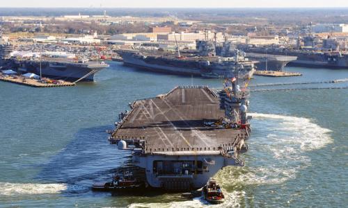
Air Station Beaufort is home to one of the largest military airstrips in the world as well as fighter and attack squadrons belonging to both the Marine Corps and the Navy.
MCRD Parris Island lies to the south of MCAS Beaufort and is one of only two installations in the nation where marine recruits are trained.
Both are projected to face increased exposure to deeper and more severe flooding as sea levels rise. In the area around Beaufort, seas are projected to rise between 4.0 and 6.4 feet by the end of this century.
The US Military on the Front Lines of Rising Seas
Base information
This location is one of 18 military installations featured in the 2016 report, "The US Military on the Front Lines of Rising Seas."
MCAS Beaufort and MCRD Parris Island are located in Beaufort County, just south of the city of Beaufort in South Carolina Lowcountry. The region is relatively low lying, particularly MCRD Parris Island, where much of the land consists of marshes.
The region is also home to US Naval Hospital Beaufort and a Marine Corps housing complex.
Projected exposure to coastal flooding
The bases' exposure to coastal flooding is projected for the years 2050, 2070, and 2100 based on the National Climate Assessment’s midrange or “intermediate-high” sea level rise scenario (referred to here as “intermediate”) and a “highest” scenario based on a more rapid rate of increase.
Tidal flooding, land loss, and storm surge from hurricanes were all modeled. In this analysis, land inundated by at least one high tide each day is considered a loss. This is a conservative metric: in reality, far less frequent flooding would likely lead to land being considered unusable.
The results below outline potential future flooding scenarios for MCAS Beaufort and MCRD Parris Island, assuming no new measures are taken to prevent or reduce flooding.
- Certain areas face daily high tide flooding. Today, tidal flooding affects low-lying locations around MCAS Beaufort and MCRD Parris Island, including extensive wetland areas, 10 times per year on average. By 2050, the currently flood-prone areas within both bases could experience tidal flooding more than 300 times annually and be underwater nearly 30 percent of the year given the highest scenario.
- Flooding during extreme high tides will become more extensive. Later this century, the higher water levels caused by extreme tides could inundate 85 percent of MCRD Parris Island’s land, both wetlands and developed areas, roughly 10 times per year given the highest scenario.
- Extensive land loss at MCRD Parris Island is possible. Parris Island is already highly prone to flooding. A projected 6.4 feet of sea level rise (the highest scenario) by 2100 would inundate three-quarters of MCRD Parris Island’s land, including developed areas, with the daily high tides.
- Sea level rise exposes previously unaffected areas of MCRD Parris Island and MCAS Beaufort to storm surge flooding. In this relatively low-lying area, sea level rise will have a substantial effect on the extent of inundation. In 2100 in the intermediate scenario, sea level rise increases the area of MCAS Beaufort exposed to flooding during all categories of storms by about 10 percent compared to today; exposure to flooding increases nearly 15 percent in the highest scenario.
- Sea level rise exposes MCRD Parris Island and MCAS Beaufort to deeper, more severe flooding. As sea level rises, the depth of inundation related to storm surge increases. In general, over time, the area inundated by five feet or more of seawater during storm surges increases. In an end-of-century worst-case scenario involving a Category 4 storm, a predicted six feet of sea level rise could double the area exposed to flood depths of 20 feet or more at MCAS Beaufort—from 17 to 34 percent of the installation.
Preparing for rising seas
The gap between the military’s current preparedness for sea level rise and the threats outlined here is large and growing.
In order to plan effectively for the long term, military decision makers with authority over MCAS Beaufort and MCRD Parris Island need to understand how sea level rise may permanently alter the landscape of these coastal installations and where the threat of storm surge may become intolerable.
To take action, however, individual installations like MCAS Beaufort and MCRD Parris Island will need more detailed analysis and resources to implement solutions.
Congress and the Department of Defense should, for example, support the development and distribution of high-resolution hurricane and coastal flooding models; adequately fund data monitoring systems such as our nation’s tide gauge network; allocate human, financial, and data resources to detailed mapping and planning efforts at military installations; and, as adaptive measures are identified, allocate resources for these projects, many of which will stretch over decades.
Our defense leadership has a special responsibility to protect the sites that hundreds of thousands of Americans depend on for their livelihoods and millions depend on for national security.
Additional maps and resources
This analysis modeled exposure to coastal flooding for four different points in time (2012, 2050, 2070, and 2100) and two different sea level rise scenarios.
For each time horizon and scenario, we analyzed storm surge from Category 1 through 5 hurricanes, the extent and frequency of flooding from extra-high tides, and inundation from ordinary high tides.
For more, please see the methodology used for this analysis.
Related resources
Applications of Climate, Energy, and Environmental Justice

Environmental, Climate, and Energy Justice—What Do They Mean?

Science and Environmental Justice